Iceland · Þingvellir National Park
Þingvellir on foot via Almannagjá, Alþingi and Öxará
A brief but insightful visit to the place where a landscape of geological faults hosted Iceland’s assembly for centuries.
Þingvellir is often added hurriedly to the Golden Circle, but it deserves a visit guided by one clear idea: it is not merely a backdrop of fissures and waterfalls, but a cultural landscape where geology, water and political history share the same route. Walking from Hakið through Almannagjá explains why the ancient Alþingi met here outdoors for centuries.
This plan works for anyone with a day trip from Reykjavík or travelling through southern Iceland by car. Leave some flexibility in your itinerary: wind, rain, ice and temporary access changes can turn an easy walk into a visit that requires a different pace.
Start up high to understand the whole site
The best starting point is Hakið, at the upper edge of Almannagjá. From the viewpoint, the descent presents the fault as a real structure in the landscape rather than an isolated photograph: below lie the assembly plains, with Lake Þingvallavatn in the distance.
Before heading down, use the visitor centre and official map to decide the order of your walk. The park has several car parks beside the main access points; if you arrive by vehicle, the fee, payment method and applicable conditions are variable details that should be checked before your visit.
The descent includes slopes and steps. Do not assume that the entire route is suitable for wheelchairs, pushchairs or people with reduced mobility: check the state of the paths and access options with the park on the same day.
Almannagjá and Lögberg: an assembly in open country
The path descends through the gorge and passes the area around Lögberg, the Law Rock. Þingvellir’s importance does not depend on a large preserved building: it becomes clear when the terrain is considered alongside the discreet remains of temporary shelters, arrival routes and the areas where people gathered.
The Alþingi was established around 930 and held its meetings at Þingvellir until 1798. Laws were proclaimed and disputes settled there; that is why the park is a cultural record, not a place valued solely for its geological spectacle.
Walk with the map in hand and pause at the information panels instead of looking for one single “main attraction”. This attention helps you avoid overlooking the turf-and-stone remains, which are fragile and often difficult to see.
Follow the water to Öxarárfoss
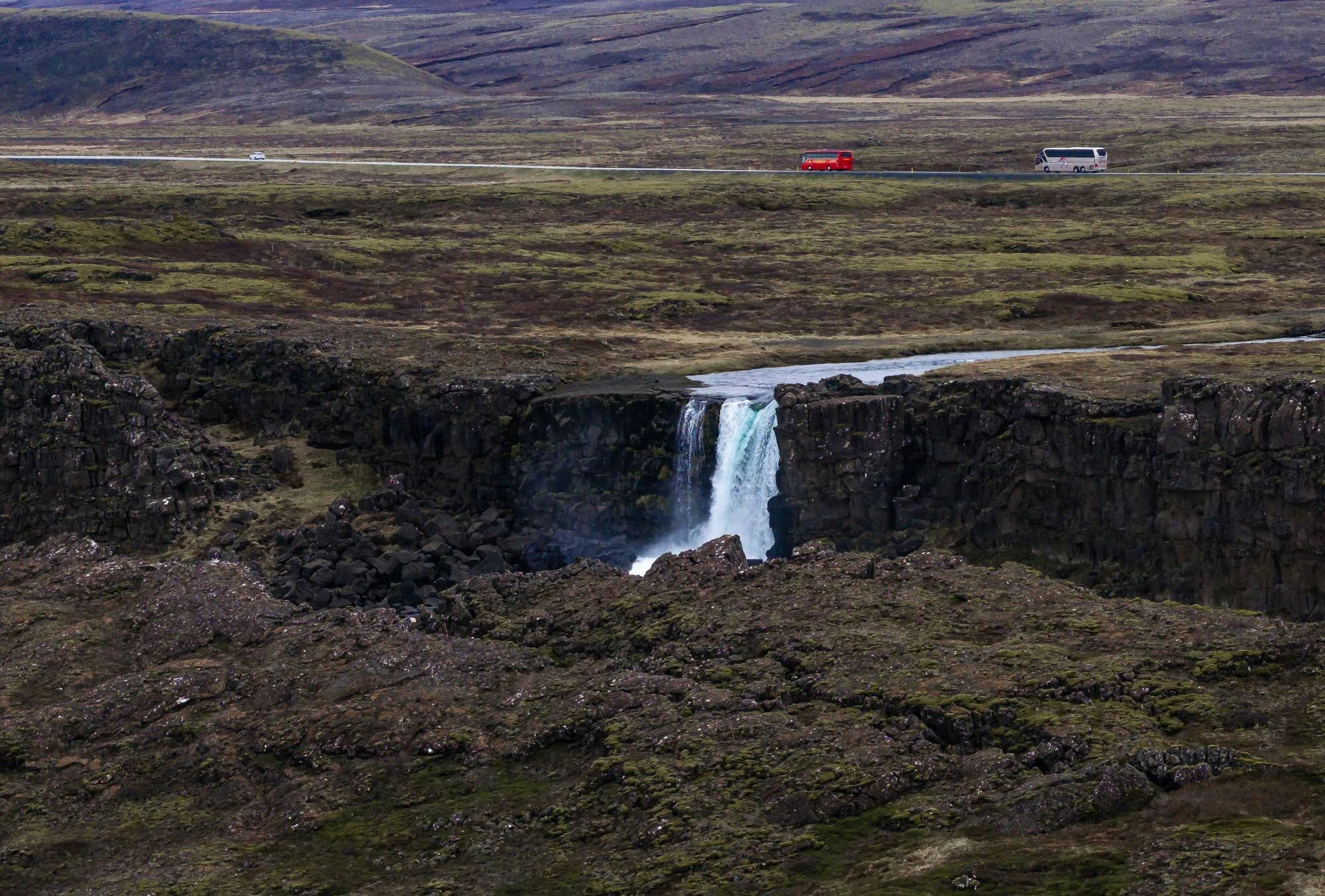
From the assembly area, continue towards Öxarárfoss, where the Öxará River drops into the fault. The waterfall helps explain that this was not an unchanging landscape: variations in flow, erosion and changes in ground level have shaped the site over centuries.
Öxarárfoss changes appearance with rainfall, snowmelt and dry periods. In winter conditions, the path may be slippery; do not make the waterfall a compulsory objective if the park reports ice, closures or damaged surfaces. Good-grip footwear, windproof layers and enough time to return without rushing are more useful choices than adding another stop to the Golden Circle.
Stay on the platforms and marked paths. The banks, vegetation and archaeological remains are all part of the same protected site.
Cross the plains with a second perspective
If the bridges and paths are open, the natural continuation is across the plains towards Flosagjá, Þingvellir church and the old farm. This section changes the scale: after the walls of Almannagjá and the roar of the waterfall come meadows, waterways and buildings that recall how the site continued to have religious, agricultural and symbolic uses.
You do not need to snorkel at Silfra to appreciate the underground waters and fissures in this area. If that activity is part of your plan, treat it as a separate excursion: confirm its requirements, equipment, meeting point and weather conditions with the authorised provider.
For a more relaxed visit, finish here and return along the route the official map marks as open. Long detours through former farms only make sense if you have daylight, suitable clothing and the desire to walk beyond the central historic circuit.
Practical decisions to make on the day
Road access and path conditions are departure-day considerations, not details to resolve when booking the trip. Check the official road information for Route 36 and the park’s notices; also review the forecast and national weather alerts before setting out from Reykjavík or your accommodation.
If there are warnings for wind, precipitation, ice or reduced visibility, limit the plan to open areas close to the car park, or postpone the visit. In Iceland, a short itinerary does not remove the need to adapt driving and walking to actual conditions.
Avoid flying a drone in the main visitor area unless you have checked the current rules. The park restricts these flights in specific zones to protect other people’s experience and the environment; regulations can change, so verify them before take-off.
Official references to check before setting out
- Þingvellir National Park: trail map, car-park locations, visitor-centre information, closure notices and drone regulations.
- UNESCO, Þingvellir National Park: context on the Alþingi, the assembly remains and the site’s inscription as a cultural landscape.
- Icelandic Road and Coastal Administration traffic information service: conditions and notifications for Route 36 to Þingvellir.
- Icelandic Meteorological Office: current forecast, wind and weather alerts.
- Visit Iceland: Þingvellir’s place within the Golden Circle route.
References consulted during editorial review. Times, requirements and advisories may change: always confirm with the official source.
- https://whc.unesco.org/en/list/1152/whc.unesco.org
- https://whc.unesco.org/en/tentativelists/5587/whc.unesco.org
- https://whc.unesco.org/uploads/nominations/1152.pdfwhc.unesco.org
- https://whc.unesco.org/en/tentativelists/5588/whc.unesco.org
- https://whc.unesco.org/en/tentativelists/5588whc.unesco.org
- https://whc.unesco.org/en/culturallandscape/whc.unesco.org
- https://whc.unesco.org/en/statesparties/iswhc.unesco.org
- https://www.thingvellir.is/en/education/news/general-news/closedtrails/www.thingvellir.is
- IslandiaWikidata · CC0 1.0 · Wikidata · Q189
- IslandiaWikidata · CC0 1.0 · Wikidata · Q3452395
- IslandiaWikidata · CC0 1.0 · Wikidata · Q2049988
- IslandiaWikidata · CC0 1.0 · Wikidata · Q19414184
- IslandiaWikidata · CC0 1.0 · Wikidata · Q3740828
- Bouvet IslandWorld Countries — mledoze · ODbL 1.0 · World countries dataset by mledoze and contributors · ODbL 1.0
- IcelandWorld Bank Open Data · CC BY 4.0 · World Bank