Lesotho · Highlands
Planning a visit to Katse Dam in Lesotho’s Highlands
At Katse, the dam, reservoir and botanical garden help explain a mountain landscape transformed by a binational water project.
Conditions described in the guide: confirm current requirements and access with the official source before travelling.
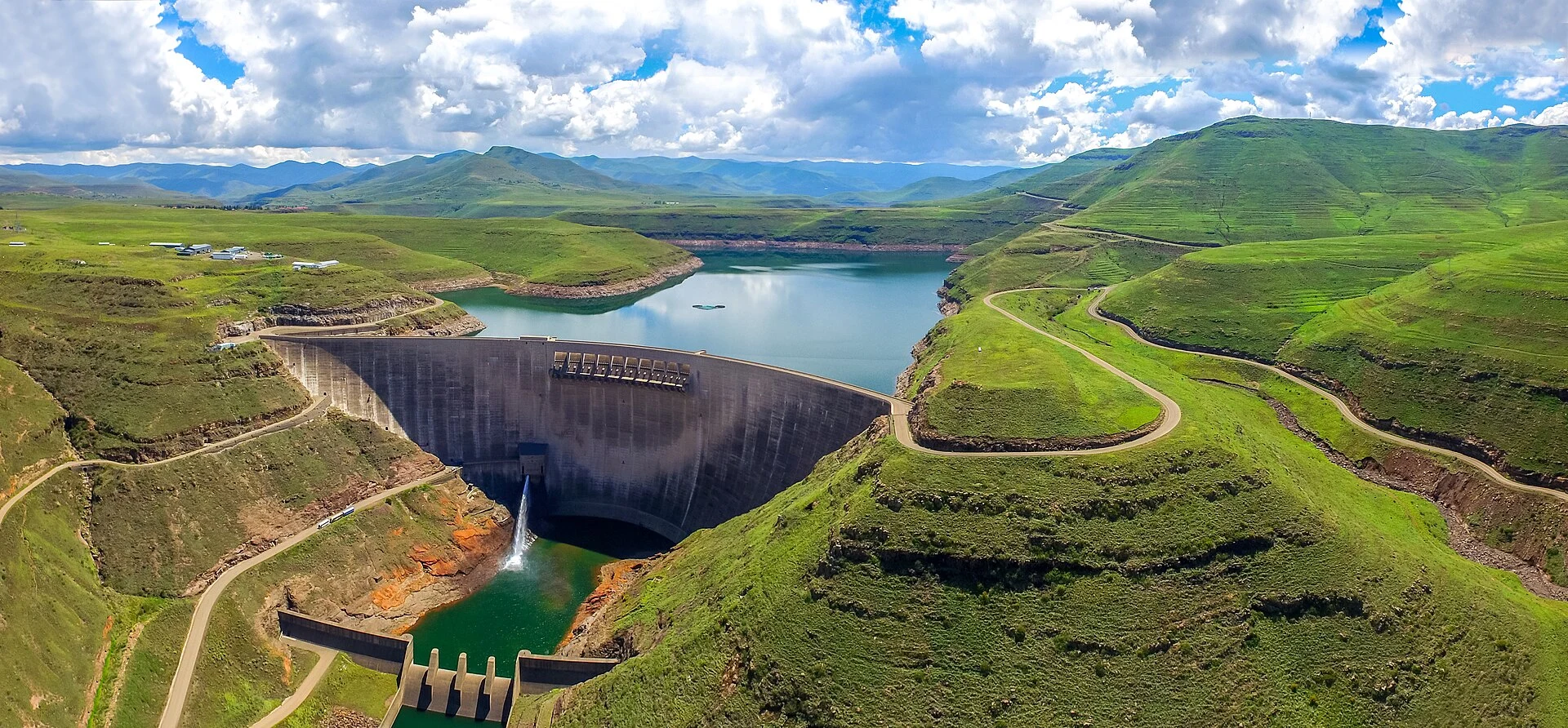
Katse is not a stop for photographing a major piece of infrastructure before carrying on. The dam and reservoir offer a way into a central question of Lesotho’s highlands: how water is collected, transferred and managed in an inhabited mountain territory. Stay overnight if you can, make the dam visit the focus of your day and leave time for the Katse Botanical Garden. This allows the landscape to acquire human, ecological and infrastructural scale rather than remaining a merely scenic backdrop.
A base for seeing the dam without turning it into a rushed stop
Katse Village is the practical base for visiting the dam. The managing authority’s programme includes a presentation on the Lesotho Highlands Water Project and guided visits to the dam wall; these are the best starting points if you want to understand what you are seeing, not simply view it from a lookout.
The dam is a 185-metre double-curvature concrete arch built across the Malibamatso River. The reservoir and access roads are part of active infrastructure, not a heritage complex detached from its function. It is therefore best to plan the day around a confirmed visit time, rather than the other way round.
Timetables, booking requirements, possible operational restrictions and accommodation availability can change. Confirm them directly with the Lesotho Highlands Development Authority before setting out.
The project that gives the reservoir its meaning
Katse forms part of the Lesotho Highlands Water Project, an initiative agreed between Lesotho and South Africa. Its first phase combined Katse Dam, transfer tunnels and the ‘Muela hydropower station: the water serves both electricity generation and regional transfer purposes.
This is the key to paying closer attention during a visit. The expanse of water is not the same as a natural lake, and the road that brings you here is not simply a tourist access route. Both are the result of technical, political and territorial decisions. A presentation by the LHDA helps place the dam within that system before you walk along the wall.
A single visit does not have to settle the debate over large water infrastructure, but it is worth recognising that its effects are not abstract. The project’s environmental assessments addressed risks to waterways, vegetation and local livelihoods, along with compensation and resettlement measures. Viewing Katse in that context avoids an incomplete reading of the landscape.
The botanical garden provides a plant-level perspective
Katse Botanical Garden is in the village and brings together indigenous plants from Lesotho, including species rescued from the area that was submerged by the reservoir. Visit it after the dam rather than treating it as an optional extra: this is where the valley’s transformation becomes tangible and where it makes sense to slow down.
The garden provides a useful counterpoint to the concrete wall. Instead of searching for a checklist of species, use it to notice high-altitude flora, medicinal plants and the conservation work associated with a large-scale project. Respect the paths and signs; do not collect plants or turn work and cultivation areas into photographic sets.
Getting there: decide according to mountain conditions, not the map
Katse works best as part of a road itinerary with plenty of time in hand, rather than as a rigid day trip from Maseru. Mountain passes can lengthen journeys, and winter conditions have led to temporary closures on routes into the highlands, including Mafika Lisiu Pass.
Do not assume that a road shown as open in an app will still be passable the next day. Before leaving, check the route conditions with the local authorities and the LHDA, especially if snow, ice, heavy rain or fog is forecast. Bring warm clothing for temperature changes, enough fuel not to depend on a single stop and enough flexibility to change your plans.
A car-free visit or public-transport route is not presented here because the sources consulted do not confirm a regular, practical connection for independent travellers. If you do not drive, book a transfer or excursion with an operator that confirms the pick-up point, route and return in writing.
A more responsible way to spend time in Katse
Treat Katse as a place where people live and work, not as a remote backdrop. Ask permission before photographing people, homes, livestock or local activities; purchase services only when their terms are clear; and do not present activities requiring prior agreement, such as horse rides, as spontaneous experiences.
The dam can take up a few hours, but the value of staying overnight lies in separating the technical visit from time spent observing the reservoir and garden. It means covering fewer kilometres, but it is more consistent with a territory where weather, roads and infrastructure can alter the day you had planned.
References to check before travelling
- Lesotho Highlands Development Authority: tourism information for Katse, dam-wall visits, the botanical garden and operational contacts. Check timetables, bookings and access to the site here.
- Lesotho Ministry of Natural Resources: institutional explanation of the Lesotho Highlands Water Project and its binational character.
- World Bank: historical environmental assessment of Phase 1B, useful for understanding the measures planned in response to social and environmental impacts.
- Lesotho News Agency and road authorities: recent notices on closures and reopenings of Mafika Lisiu Pass. Check the route status immediately before travelling.
References consulted during editorial review. Times, requirements and advisories may change: always confirm with the official source.
- https://environment.gov.ls/protected-places/bokong-nature-reserve/environment.gov.ls
- https://www.bos.gov.ls/new%20folder/Environment%20and%20Energy/2017_Environment_Report.pdfwww.bos.gov.ls
- https://environment.gov.ls/download/bokong-nature-reserve-management-plan/environment.gov.ls
- https://environment.gov.ls/environment.gov.ls
- https://www.lhda.org.ls/home/tourismwww.lhda.org.ls
- https://www.gov.ls/wp-content/uploads/2022/03/Third-National-Communication.pdfwww.gov.ls
- https://www.gov.ls/wp-content/uploads/2020/11/Expression-of-Interest-Bokong-October-2020-1.pdfwww.gov.ls
- https://www.bos.gov.ls/New%20Folder/Environment%20and%20Energy/2022_Environment_Report.pdfwww.bos.gov.ls
- LesotoWikidata · CC0 1.0 · Wikidata · Q1013
- LesothoWorld Countries — mledoze · ODbL 1.0 · World countries dataset by mledoze and contributors · ODbL 1.0
- LesothoWorld Bank Open Data · CC BY 4.0 · World Bank
- LesothoDBpedia · CC BY-SA 3.0 · DBpedia
- Exploring the congruence between the Lesotho junior secondary geography curriculum and environmental educationOpenAlex · CC0 1.0 · OpenAlex