Djibouti · Nature with context
Salt and Volcanic Landscapes at Lake Assal
At Lake Assal, white does not mean just one thing. There is crystallized salt, brine, working routes and a protected landscape shaped by heat and desert logistics. This guide offers a clearer visit: go to understand the rift, respect active areas and plan the return before descending to the lake.
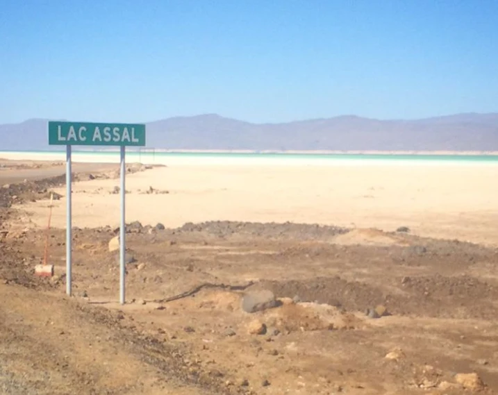
Lake Assal is often reduced to a photograph of turquoise water and a white crust. The image is accurate, but incomplete: the lake is a depression in the Afar Rift, about 153 metres below sea level, with extremely mineral-rich waters, dark lava, hot springs and an extensive salt plain. It is also a protected area and a place where salt forms part of a regulated economic activity. Visiting well is less about “conquering” an extreme landscape than about distinguishing its layers and accepting its limits.
The decision beforehand: go to Assal for the landscape, not for the promise of a swim
Lake Assal’s main appeal lies in the relationship between geology, hypersaline water and light: the basin forms part of the Afar Depression; the lake is separated from Ghoubbet-el-Kharab by the Ardoukôba volcano and lies within the Great Rift system. Its mineral concentration, according to the information Djibouti submitted to UNESCO, is 348 grams per litre—approximately ten times that of seawater.
That helps set expectations. This is not an equipped beach or a place designed for spending the day outdoors; it is an exposed environment, with intense glare and high temperatures. UNESCO’s own description refers to an arid climate and episodes above 55°C. If the heat, limited shade or a long day on the road would make the visit unpleasant, it is reasonable to choose another landscape in Djibouti or limit Assal to a brief, well-supported stop.
Do not plan the trip around photographs that suggest uniform access to the water. The terrain shifts between brine, salt crust, gypsum, volcanic rock and working areas. Before leaving, ask a local operator which part of the shore you will visit, how much time you will actually spend walking and whether the itinerary includes an alternative if road conditions or heat make it necessary to shorten the outing.
Three landscapes, three ways of being there
First comes the brine: the blue-green surface that gives the lake its best-known appearance. Second is the so-called banquise, or salt crust, which is not interchangeable scenery along the shore: it is a physical formation and an area with regulated uses. Third is the corridor of lava, mountains and access routes that places the lake within a tectonic landscape, not a fantasy of “endless salt”. The national tourism office also presents the contrast between white salt, black lava and the basin’s colours as the site’s visual key.
The practical consequence is simple: follow the itinerary and the area indicated by someone who knows the terrain that day. Do not cut across the crust, treat salt heaps, vehicles or loading areas as photographic props, or collect crystals as souvenirs. A specific decree distinguishes extraction, tourism and caravaner-use areas, and prohibits industrial operators from extracting salt from the banquise except in areas reserved for traditional methods.
Watching the work without interrupting it is a more respectful way to understand the site. Assal salt is not just a souvenir: it has a long history of caravan trade and remains linked to extraction, processing and transport. The visit gains depth when it addresses this coexistence—landscape, work, regulation and conservation—without asking anyone to perform a tradition for the camera.
A protected area is not an empty enclosure
Lake Assal was included among Djibouti’s terrestrial protected areas under Law No. 45/AN/04/5ème L of 2004. The law makes two points that should be held together: these areas are not automatically closed to the public, but ecotourism is authorised in a regulated and controlled manner to preserve biodiversity; local communities must also be involved in their management.
So “you can enter” does not mean “anything goes”. Keep rubbish, food and belongings off the salt surface; do not leave marks or rearrange crystals for a photograph; and ask permission before photographing people. For US travellers, the current consular alert also reminds visitors not to photograph Djiboutians without their consent and warns that photographing infrastructure, government buildings, military personnel, airports, ports, bridges, borders and mosques may lead to penalties. These rules may be applied strictly: check them before travelling.
Assal has appeared since 2015 on Djibouti’s Tentative List for World Heritage, but it is not a property inscribed on the World Heritage List. The distinction matters: the Tentative List expresses a possible future nomination, not a UNESCO designation that has already been granted.
Logistics matter more than map distance
An excursion from Djibouti City may look simple on paper, but the experience depends on the vehicle, driver, departure time and return plan. The US Department of State’s travel guidance, updated on 3 September 2026, warns that outside the capital—including the Lake Assal area—mobile coverage may be limited or nonexistent; it recommends carrying extra water, maps, fuel and a first-aid kit when leaving Djibouti City. It also notes roads with limited lighting, animals or pedestrians on the carriageway and few roadside assistance services.
The best question when booking transport is not “How much does the tour cost?” but “What happens if the vehicle breaks down or we have to return early?” Look for a transfer that confirms in advance a suitable vehicle, water for everyone, a return time before dark, route knowledge and an operational contact. Download offline maps before leaving the city, bring sun protection, light full-coverage clothing and your own water; do not assume there will be shops, signal or electronic payments at the site.
One detail to verify immediately before departure: the condition of the access roads, any local restrictions, the availability of a guide or driver, and the travel advice for your nationality. Do not base this check on an old post or a social-media itinerary. Road conditions, checkpoints and official recommendations change.
A more sensible day: observe, interpret, return
A well-planned visit can be brief. Allow enough time to walk slowly in the authorised area, observe how the colours of the water, gypsum, salt and lava change, and listen to an explanation of the rift and the salt economy. Leave time for the return journey instead of stringing together too many stops beneath the sun.
If swimming is your main interest, ask your guide for specific confirmation of the access point, the day’s conditions and the time available. If photography is your priority, focus on broad landscapes and avoid approaching operations, vehicles, people or facilities without consent. If you are interested in the material culture of salt, ask about its origin and supply chain before buying: not every white object sold near a lake explains who produced it or how it is distributed.
The result is not a less intense visit. It is a visit that does not require the site to look like a swimming pool, workers to act as extras or the desert to compensate for poor planning. At Assal, the best experience is usually the one that leaves more room for the landscape and puts less pressure on it.
References consulted during editorial review. Times, requirements and advisories may change: always confirm with the official source.
- https://www.afdb.org/sites/default/files/documents/environmental-and-social-assessments/djibouti_-_geothermic_exploration_project_-_rdge_-_esmp_summary.pdfwww.afdb.org
- https://www.journalofficiel.dj/arabe/texte-juridique/loi-n45-an-04-5eme-l-portant-creation-des-aires-protegees-terrestres-et-marines/www.journalofficiel.dj
- https://whc.unesco.org/en/statesparties/djwhc.unesco.org
- https://www.journalofficiel.dj/texte-juridique/decret-n2002-0226-pr-mern-portant-reglementation-specifique-de-lextraction-de-traitement-et-de-commercialisation-du-sel-du-lac-assal/www.journalofficiel.dj
- https://www.ramsar.org/our-work/wetlands-international-importance/ramsar-listwww.ramsar.org
- https://travel.state.gov/en/international-travel/travel-advisories/djibouti.htmltravel.state.gov
- https://whc.unesco.org/en/tentativelists/5959/whc.unesco.org
- https://www.mern.dj/index.php/component/content/article?Itemid=437&id=298www.mern.dj
- DjiboutiWorld Bank Open Data · CC BY 4.0 · World Bank
- DjiboutiDBpedia · CC BY-SA 3.0 · DBpedia