Madagascar · Andrefana dry forests
Tsingy de Bemaraha routes begin with the road to Bekopaka
In Bemaraha, the important decision is not adding viewpoints: it is choosing a circuit that matches your tolerance for exposure and leaving a genuine margin to reach Bekopaka.
Conditions described in the guide: confirm current requirements and access with the official source before travelling.
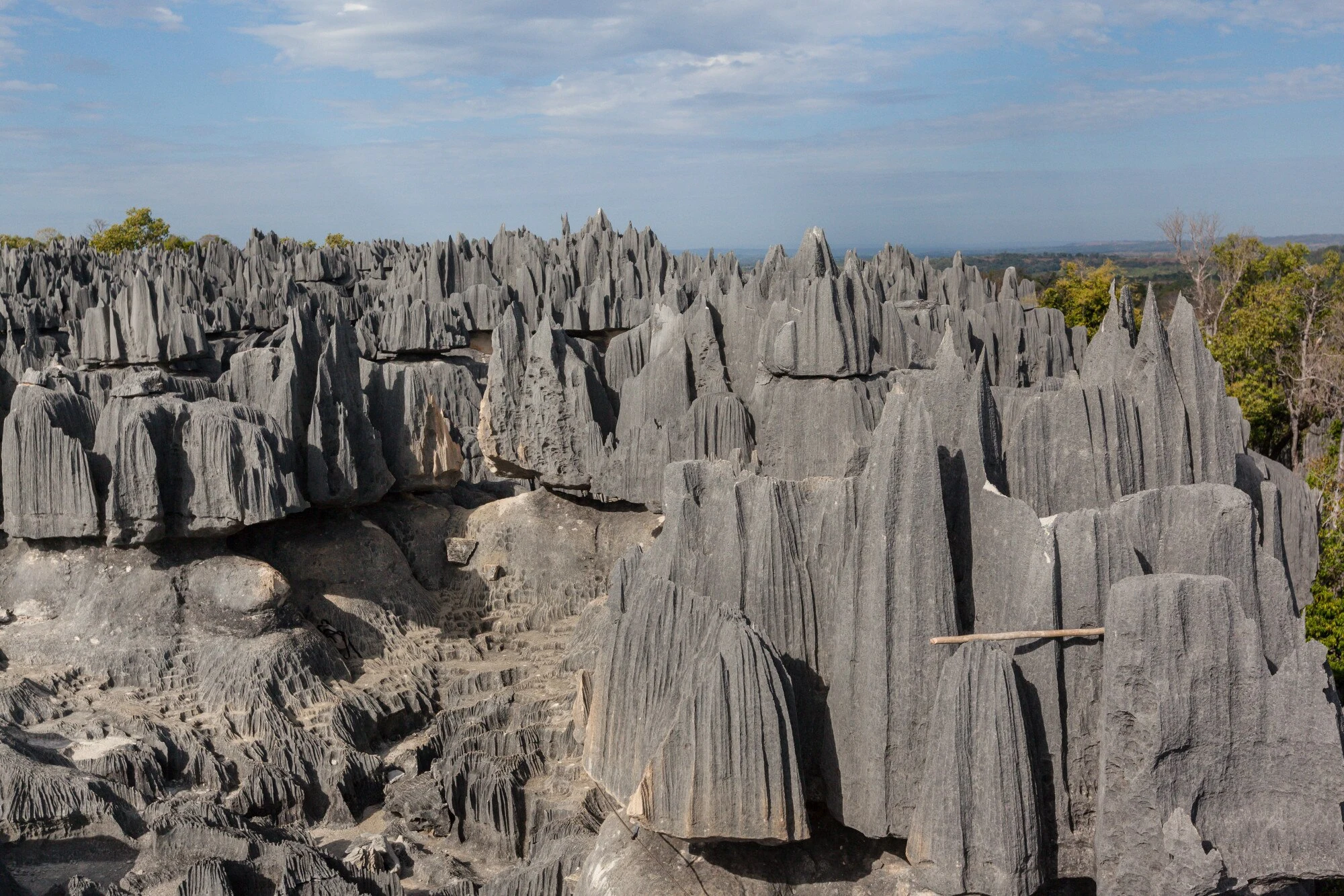
Tsingy de Bemaraha rewards a calmly prepared visit: its limestone pinnacles, canyons and dry forest form part of the Andrefana Dry Forests, a World Heritage site. But this is not a park for improvising a short excursion from the coast. The quality of the experience depends on two very specific things: the state of the overland access and an honest choice of route based on your mobility, experience on uneven ground and reaction to heights.
Bekopaka is the usual base for the park’s most visited sectors. It is worth treating the journey there as a central part of the trip, not simply as a transfer before the walk.
Listen to Madagascar
A documented soundscape that complements this guide to Madagascar. In Bemaraha, the important decision is not adding viewpoints: it is choosing a circuit that matches your tolerance for exposure and leaving a genuine margin to reach Bekopaka.
Audio by Kaluvau · Wikimedia Commons · CC BY-SA 3.0 · Duration: 01:33
Access determines the itinerary
The secondary road to Bemaraha can change radically with the rains. Institutional information indicates that, between December and April, access becomes more difficult and much of the tourist infrastructure may close; do not book connecting transport or international flights with a tight return schedule without first confirming the situation with the park administration and your overland operator.
Reaching the park from the west requires a suitable vehicle, a driver with local experience and plenty of leeway for delays. Consular authorities also warn that road journeys in Madagascar can be slow, road conditions are uneven and driving at night adds risks. For this destination, an organised route is not a narrative luxury: it may be a prudent logistical decision.
Before paying, check with the official Madagascar National Parks page whether the park, river crossings and the circuit you want are operating on your dates. Also confirm where each day will end, which meals and water are included, and what happens if the road prevents you from reaching Bekopaka.
Start with the Petits Tsingy, not the highest photo spot
The Andadoany circuit is a good first measure of the terrain. Although it is short, the park administration presents it as a trial route: it combines labyrinths, climbs and exposure to the void, and takes around four hours of walking. It is useful for deciding, once on the ground, whether it makes sense to aim for more demanding options afterwards.
Ankeligoa broadens the experience with canyons, narrow passages, caves and viewpoints; it is rated as moderate difficulty and takes approximately five hours. Do not choose by kilometre count: in a karst landscape, progress can be slow because of uneven rock, passageways and changes in elevation. Wear shoes with good grip, sun protection and carry enough water in a backpack that leaves your hands free.
If vertigo, a recent injury or insecurity on exposed surfaces concerns you, plan the day around Andadoany and the river. Skipping a walkway does not make the visit incomplete: it allows you to experience the place at a pace your body can sustain.
The Grands Tsingy are physical activity, not a scenic stroll
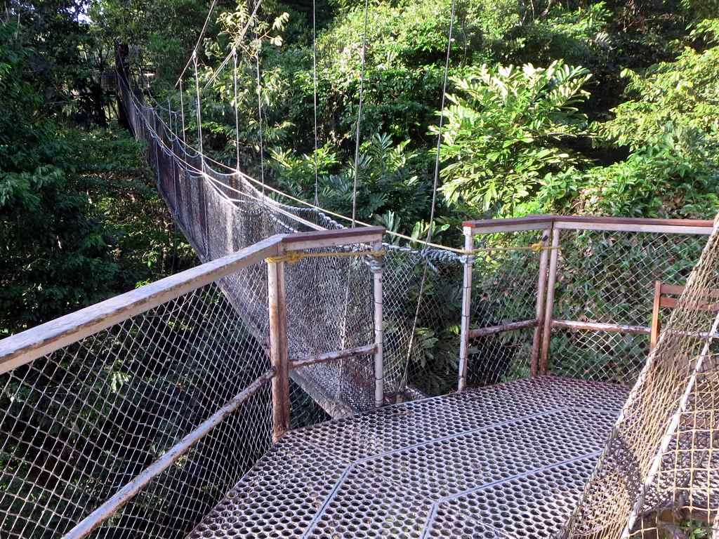
Andamozavaky leads towards large limestone formations, fissures, arches and an elevated viewpoint. The park classifies it as difficult and athletic, taking around four hours despite the route being roughly four kilometres long. It includes a crossing over a suspended bridge above a considerable drop; the challenge lies in the type of terrain, not the distance.
Ranotsara, north of Bekopaka, and Broadway, which combines several sectors, are also listed as difficult routes. They are options for travellers who move confidently across uneven rock and accept a day of sustained physical concentration. Do not schedule them on the same day as a long transfer: leaving an afternoon to rest in Bekopaka improves both safety and your ability to enjoy the scenery.
Ask at reception what equipment is required or provided that day, and follow staff instructions on bridges, ladders and narrow sections. Operating conditions, the state of the passages and circuit availability are changing facts that must be reconfirmed when you arrive.
The Manambolo reveals another scale of the landscape
The Manambolo Gorge offers an alternative that explains why Bemaraha is more than its pinnacles. The gorge circuit combines a dugout canoe, caves and views of limestone walls and riverside vegetation; the park’s information sheet rates it as moderate difficulty and shorter than the major walking routes.
The crossing passes by Vazimba tombs. Do not treat them as scenery or as a stop for producing images: listen to the local explanation, ask before taking photographs and respect any cultural or access guidance. This dimension helps show that the river, caves and rock formations also belong to a social landscape shaped by memory.
Travellers with one full day can combine a moderate route through the Petits Tsingy with the Manambolo, provided local schedules allow it. Those with more time can separate the river and the Grands Tsingy onto different days, a more sensible choice than piling on the exertion.
A visit with room to spare protects both the trip and the place
Bemaraha contains highly endemic dry-forest ecosystems and a fragile landscape. Stay on marked routes, avoid removing stones, plants or any remains from the caves, and do not chase animals for a photograph. Silence and distance are usually better observation tools than moving closer.
Take your rubbish back to Bekopaka when no visible collection system exists, reduce single-use plastic before setting out and do not assume there will be phone coverage, cash, electricity or medical services near the trails. Healthcare outside the main cities may be limited.
This destination is best suited to a trip with buffer days, flexible expectations and a willingness to adapt the plan to the road, weather and park guidance. If your schedule cannot tolerate changes, it may be better to choose another part of Madagascar this time.
References consulted during editorial review. Times, requirements and advisories may change: always confirm with the official source.
- https://parcs-madagascar.com/en/parc/tsingy-de-bemaraha-2/parcs-madagascar.com
- https://whc.unesco.org/en/list/494whc.unesco.org
- https://whc.unesco.org/document/153579whc.unesco.org
- https://whc.unesco.org/en/documents/104118whc.unesco.org
- https://parcs-madagascar.com/parc/tsingy-de-bemaraha/parcs-madagascar.com
- https://whc.unesco.org/en/statesparties/mg/assistancewhc.unesco.org
- https://whc.unesco.org/en/news/2112whc.unesco.org
- https://whc.unesco.org/en/decisions/3557/whc.unesco.org
- MadagascarWikidata · CC0 1.0 · Wikidata · Q1019
- MadagascarWikidata · CC0 1.0 · Wikidata · Q174555
- MadagascarWikidata · CC0 1.0 · Wikidata · Q3496405
- MadagascarWorld Countries — mledoze · ODbL 1.0 · World countries dataset by mledoze and contributors · ODbL 1.0
- MadagascarWorld Bank Open Data · CC BY 4.0 · World Bank
- MadagascarDBpedia · CC BY-SA 3.0 · DBpedia