Exploring the Temples and Canals of Muara Jambi from Jambi
Muara Jambi is neither a photo stop nor a single temple: it is a vast, inhabited, riverine archaeological landscape. This guide proposes a one-day visit from Jambi that prioritizes realistic distances, Buddhist context and basic care, so restored ruins are not mistaken for a contained archaeological park.
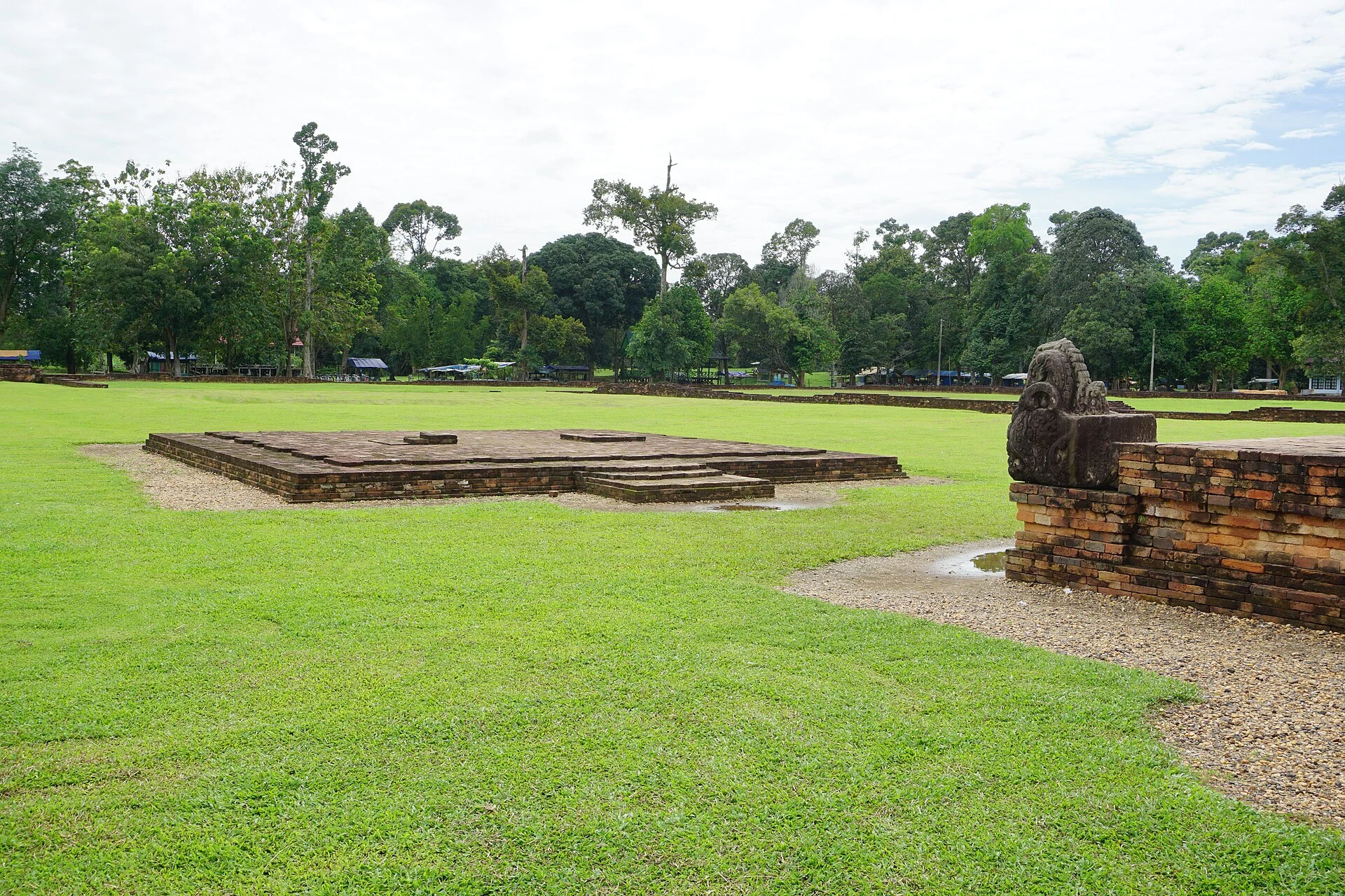
On the banks of the Batanghari, Muara Jambi brings together brick structures, archaeological mounds—menapo—ponds, canals and present-day villages across an area of almost 4,000 hectares. Its scale changes the practical question: the aim is not to “see all the temples”, but to choose one section, move at an unhurried pace and read how water organizes the site. Indonesia submitted its nomination to UNESCO’s Tentative List on 15 April 2025; as of 5 September 2026, it must not be presented as an inscribed World Heritage Site.
Visual context for IndonesiaContext video selected for this guide; it does not by itself identify every place mentioned.Video by Mosquegrapher · Pexels · Pexels License · Duration: 00:19
♫
Listen to Indonesia
A documented soundscape that complements this guide to Indonesia. Muara Jambi is neither a photo stop nor a single temple: it is a vast, inhabited, riverine archaeological landscape. This guide proposes a one-day visit from Jambi that prioritizes realistic distances, Buddhist context and basic care, so restored ruins are not mistaken for a contained archaeological park.
Cultural or ambient audio selected as context; it does not necessarily represent every place mentioned. Audio by RTB45 · Openverse · CC BY 4.0 · Duration: 04:4701
The key decision: visit a landscape, not a collection of monuments
The complex stretches across several villages and preserves more elements than the brick sanctuaries usually seen in photographs. UNESCO documentation identifies structures, ponds, canals, former settlements and numerous menapo; recent research emphasizes that the water system and flood-prone areas are part of the archaeological context, not merely scenic background.
A satisfying visit therefore does not need to cover everything. Set aside a full day from Jambi city and arrange round-trip transport in advance. The official tourism portal places the complex approximately 30 km northeast of Jambi, but that figure does not turn the internal route into a short walk: the different groups are separated by paths, vegetation, canals and stretches exposed to the sun.
The trade-off is clear: visitors seeking continuous museum-style signage, frequent cafés or a fully accessible route will find this more demanding than Java’s major complexes. Those willing to move slowly will encounter an unusual territorial scale for understanding Sumatra’s Buddhist history.
02
A one-day itinerary: three stops are enough
Start with Candi Gumpung and Candi Tinggi. They are good entry points for observing the proportions of the brickwork, the platforms and the relationship between excavated buildings and the surrounding terrain. Archaeological research links several of the main monuments, including Gumpung and Tinggi, with Buddhist traditions; however, avoid assuming an exact function for every wall or mound where there is no interpretation on site.
Continue towards Kembarbatu, Astano or Gedong I and II, depending on the time available and the condition of the road. Do not turn the route into a checklist: choose one or two additional groups and leave time to stop by ditches, canals and changes in elevation. The distribution of the sites explains why a linear walk is a poor strategy; the protected area covers several villages and its documented remains are scattered along a broad corridor.
Finish beside the Batanghari or at a shaded spot, without chasing the sunset at any cost. Muara Jambi’s value lies in connecting water, settlement and architecture. Research on local memory also warns that seasonal flooding and tides have historically shaped life in the area. If the ground is waterlogged, reshape the day: make fewer stops, spend more time in accessible sectors and do not force your way off the established route.
03
How to read the site more precisely
The phrase “the largest Buddhist university” may work as an image, but it is best treated as a historical interpretation, not an automatic tourism label. The proposal submitted to UNESCO describes Muarajambi as an important centre of Buddhist religion and education between the 7th and 14th centuries, connected to Asian exchange networks. Recent archaeological studies place several uses of the area between the 7th and 12th centuries. The differing chronologies reflect the fact that they refer to different evidence, buildings and occupation phases.
A more responsible reading focuses on what the terrain can support: fired brick, ditches, platforms, mounds that have not yet been excavated and a water network that was not necessarily navigable at all times. This avoids imagining the complex as a monumental city frozen in time and recognizes it as a living landscape, gradually researched and conserved.
04
What to prepare before leaving Jambi
Bring reusable water, protection from sun and rain, grippy footwear and a light layer covering your shoulders and legs. This is not a universal ceremonial requirement announced for the entire site, but a sensible choice for walking over earth, grass and uneven surfaces in a place of Buddhist and community significance.
For visitors with reduced mobility, strollers or balance difficulties, the realistic option is to plan a partial vehicle-based visit and confirm locally which sectors have firmer access; do not assume continuous walkways or adapted toilets. Do not climb walls, touch bricks, enter closed areas or use drones without permission: conservation is ongoing, and many menapo are archaeological deposits, not hills to explore.
Check before travelling: opening hours, admission fee, road conditions, guide availability, toilets, photography or drone restrictions and temporarily closed sectors. These operational details can change; cross-check them with the official Indonesia Travel portal and the local cultural administration before setting out.
05
The traveller’s best contribution: reduce your footprint, do not seek exclusivity
Muara Jambi does not need the “secret site” narrative. It is a national cultural area with resident communities, conservation activity and environmental and land-use pressures identified in its nomination documentation. Hiring a local driver or guide where possible, buying food from local businesses, leaving no waste and following the instructions of those responsible are more useful gestures than trying to reach isolated sectors.
If you have two nights, sleep in Jambi rather than compressing the visit between flights. Not because the complex needs to be “conquered”, but because the extra margin makes it possible to cancel or shorten the day sensibly if it rains, the heat becomes intense or access conditions change.
Sources and checks
References consulted during editorial review. Times, requirements and advisories may change: always confirm with the official source.