Sonora, Mexico
El Pinacate’s craters and dunes require different plans
The best way to plan a visit to El Pinacate is to consider the type of landscape, the vehicle available and your tolerance for heat—not simply a list of stops.
Conditions described in the guide: confirm current requirements and access with the official source before travelling.
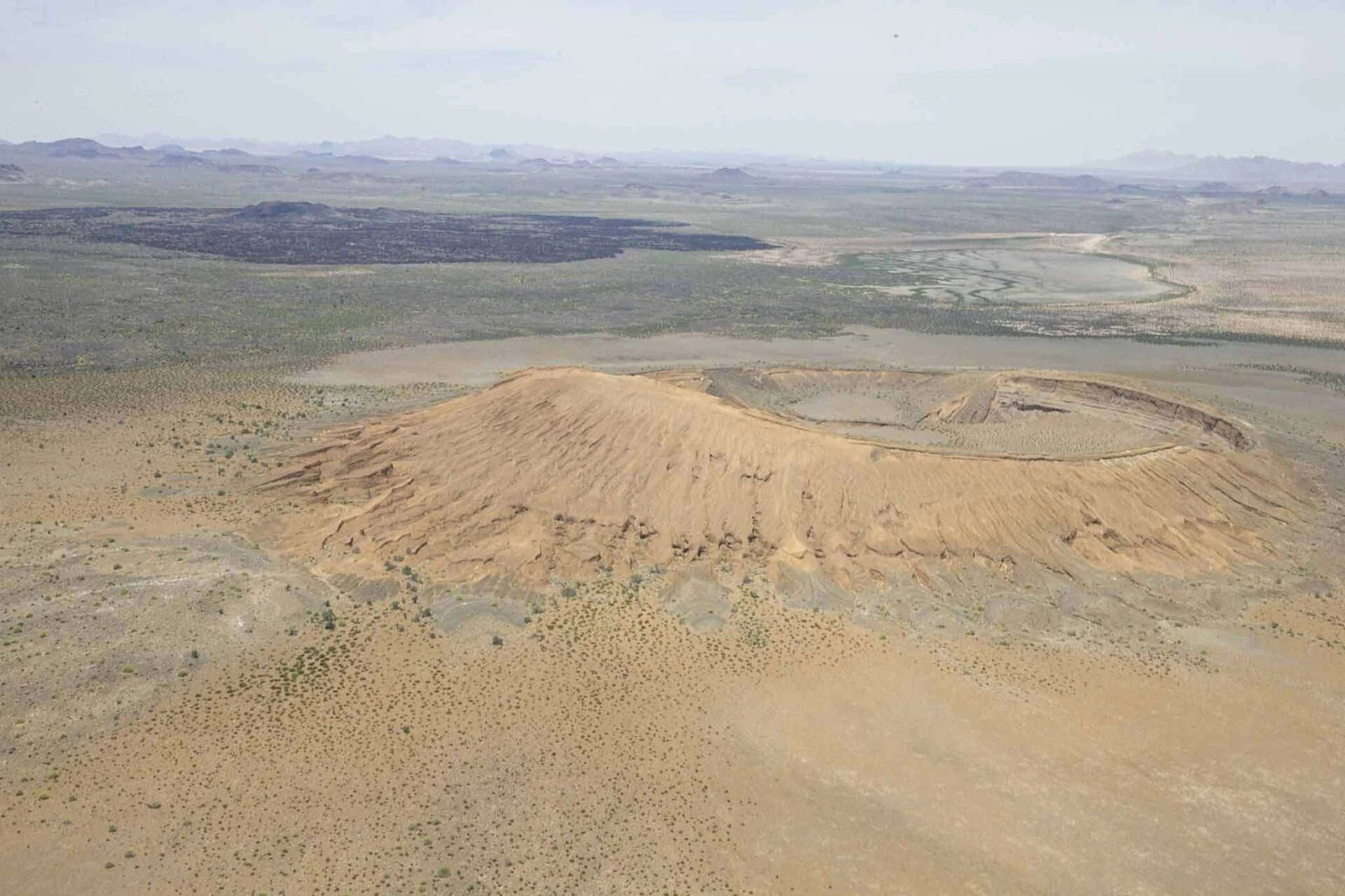
El Pinacate and Gran Desierto de Altar is not a park you experience through a series of immediate viewpoints: it is an extensive reserve where logistics shape the experience. The practical decision is simple—but important: devote the day to the craters and lava flows, or hike toward the active dunes from Schuk Toak. Both options reveal very different landscapes and require different kinds of preparation.
Listen to Mexico
A documented soundscape that complements this guide to Mexico. The best way to plan a visit to El Pinacate is to consider the type of landscape, the vehicle available and your tolerance for heat—not simply a list of stops.
Audio by Lenguaverde · Openverse · CC0 1.0 · Duration: 02:31
Two access points, two ways of understanding the reserve
The Biological Station is the registration point for entering the reserve’s vehicle route; from there, a dirt-road circuit connects the El Elegante, El Tecolote and Cerro Colorado craters. It is the right option for visitors with a vehicle who want to read the terrain as a volcanic landscape: dark lava, cones, craters and wide-open distances.
The Schuk Toak Museum and Visitor Center works better as a first stop for those seeking context and a more contained walk. Its short trails help visitors identify the geology, vegetation and desert conditions before setting out on a longer route. Trying to cover both areas in a hurry is not advisable: choosing one lets you adjust your water supply, driving time and effort without turning the day into a race.
Craters: the option for traveling with your own vehicle
The internal route to the craters covers approximately 72 kilometers of dirt road and passes through areas without services. Reserve authorities warn that the roads may include rocky stretches and water crossings; for several areas they recommend a high-clearance vehicle, while access to El Tecolote may be possible for low-clearance cars if conditions allow.
The reward is not a collection of monumental viewpoints, but a sense of scale: El Elegante offers a view of a maar-type crater, while the surrounding landscape shows how water, magma and erosion shaped the volcanic shield. Drive slowly, stay on marked routes and do not descend into the craters. Leaving the road compacts fragile soils and damages both natural and cultural remains.
If you are traveling without a car, there is no regular public transportation from Puerto Peñasco to the reserve. A taxi or local operator may solve the transfer, but confirm in advance whether it includes the internal route and what type of vehicle is used.
Dunes: a short walk on the map, a demanding one on the ground
The trail from Schuk Toak toward the Gran Desierto de Altar covers about five kilometers and takes an estimated three hours, with a moderate difficulty level. On sand and under direct sun, that distance demands more than an urban walk: bring enough water, sun protection and closed shoes, and allow enough time to return before the heat intensifies.
Access to this trail is restricted to the October-to-May season because of high temperatures. It is not a route to improvise in summer or start late in the day. When you register, follow staff guidance on the schedule, trail conditions and the day’s circumstances; these may change because of heat, wind or operational capacity.
The dunes are not an empty backdrop. Their movement and origin—linked to sediments from the Colorado River, the coast and local alluvial fans—explain why the landscape changes so dramatically within just a few kilometers.
A cultural landscape that should not be treated as an uninhabited ruin
El Pinacate’s value is not limited to geology. The territory preserves traces of human occupation and remains significant to O’odham peoples, including the Tohono O’odham and Hia C’ed O’odham. Ancient trails, water sources and archaeological remains make it clear that this desert has been traveled, understood and cared for over a long period of time.
Two common mistakes should be avoided: taking stones or other materials as souvenirs, and presenting Indigenous traditions as something belonging exclusively to the past. Some places and practices hold ceremonial value; visitors should not seek access to sensitive areas or turn them into a spectacle. The most practical way to show respect is to follow the regulations, remove nothing and treat the visitor center as an introduction—not a substitute for that cultural context.
A realistic plan: a day trip or a simple night of camping
For a first visit, plan one main experience and return to Puerto Peñasco the same day. Those who want to spend the night can use the designated areas at El Tecolote and Cono Rojo, but these are service-free areas with limited capacity: arrive with water, food, equipment, fuel and a return plan.
Camping does not eliminate the need for planning. Descending into craters, lighting fires outside authorized places and removing plants, animals, sand, rocks or cultural materials are prohibited in the reserve. All rubbish must leave with you. This self-sufficiency is not an adventure aesthetic: it is the minimum condition for the site to withstand visitation.
Before setting out, check the forecast, tell someone else your route and do not assume continuous phone coverage. If your available day is short, the interpretive walk at Schuk Toak may be a wiser choice than taking the full route into the reserve.
Official sources to check before traveling
Check the entrance fee, opening hours, closures, registration requirements, dirt-road conditions, vehicle requirements, availability of guided tours and access to the dune trail on the same day or a few days before your trip. The main references are the reserve listing in Descubre ANP by CONANP, the regulations and visitor information for the El Pinacate and Gran Desierto de Altar Biosphere Reserve, the UNESCO listing for the natural property and the territorial overview from the National Institute of Anthropology and History.
References consulted during editorial review. Times, requirements and advisories may change: always confirm with the official source.
- https://conanp.gob.mx/conanp/dominios/pinacate1/sitios_de_interes.phpconanp.gob.mx
- https://www.gob.mx/conanp/es/articulos/museo-schuk-toak-un-espacio-seguro-para-conocer-el-desierto-sonorensewww.gob.mx
- https://conanp.gob.mx/conanp/dominios/pinacate1/visitantes.phpconanp.gob.mx
- https://www.gob.mx/conanp/prensa/areas-naturales-protegidas-sitios-para-conocer-y-disfrutar-24281?idiom=es-MXwww.gob.mx
- https://www.gob.mx/conanp/articulos/espacios-de-cultura-ambiental-cabo-pulmo-sierra-de-san-pedro-martir-y-el-pinacate?idiom=eswww.gob.mx
- https://whc.unesco.org/en/list/1410whc.unesco.org
- https://descubreanp.conanp.gob.mx/es/conanp/ANP?suri=57descubreanp.conanp.gob.mx
- https://conanp.gob.mx/conanp/dominios/pinacate1/educacion.phpconanp.gob.mx
- MéxicoWikidata · CC0 1.0 · Wikidata · Q96
- MéxicoWikidata · CC0 1.0 · Wikidata · Q55712
- MexicoWorld Countries — mledoze · ODbL 1.0 · World countries dataset by mledoze and contributors · ODbL 1.0
- MexicoWorld Bank Open Data · CC BY 4.0 · World Bank
- MexicoDBpedia · CC BY-SA 3.0 · DBpedia
- Turismo en pueblos mágicos de México. Impactos y retos rumbo a la sostenibilidadCrossref · Metadatos públicos; derechos específicos por campo cuando correspondan · Crossref
- Sostenibilidad del turismo y planeación municipal en MéxicoCrossref · Metadatos públicos; derechos específicos por campo cuando correspondan · Crossref
- Sostenibilidad del turismo y política pública: consideraciones desde la seguridad ciudadana y limpieza en pueblos mágicos de chiapasCrossref · Metadatos públicos; derechos específicos por campo cuando correspondan · Crossref
- Sostenibilidad y comunidad: El éxito de gestión de la Cooperativa Tosepan Kali en el Pueblo Mágico de Cuetzalan, PueblaCrossref · Metadatos públicos; derechos específicos por campo cuando correspondan · Crossref
- Rafael Lemus, Breve historia de nuestro neoliberalismo. Poder y cultura en México. México: Debate, 2021, 231 p.Crossref · Metadatos públicos; derechos específicos por campo cuando correspondan · Crossref
- La competitividad turística ante los retos de sostenibilidad en los pueblos mágicos, análisis de santiago, nuevo leónCrossref · Metadatos públicos; derechos específicos por campo cuando correspondan · Crossref
- Reseña bibliográfica: Perrot, Michelle, Historia de las alcobas, Fondo de Cultura Económica, México, 2011, 353 pp.Crossref · Metadatos públicos; derechos específicos por campo cuando correspondan · Crossref
- Semblanzas del Estado de México en la obra de Ignacio Manuel AltamiranoOpen Library · CC0 1.0 (registros de catálogo) · Open Library
- Tradición y modernidad en MéxicoOpen Library · CC0 1.0 (registros de catálogo) · Open Library